|
|
|||||||||||||||||
| Point ID: 9048 | Downloads | Plots | Site Data | Code: 49009 |
|
|
|||||||||||||||||
| Download | |
|---|---|
| Site Descriptor Information | Site Time Series Data |
| Link to all available data | |
| View: | Time Series | All |
| Units: | mm |
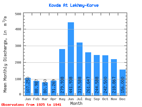
| Statistic | Jan | Feb | Mar | Apr | May | Jun | Jul | Aug | Sep | Oct | Nov | Dec | Annual |
|---|---|---|---|---|---|---|---|---|---|---|---|---|---|
| Mean | 107.25 | 88.99 | 80.15 | 91.27 | 279.94 | 441.94 | 319.59 | 261.65 | 244.59 | 242.50 | 218.87 | 156.00 | 214.68 |
| Standard Deviation | 27.21 | 21.53 | 16.72 | 21.96 | 87.39 | 87.78 | 62.91 | 56.47 | 68.81 | 94.49 | 76.03 | 43.45 | 37.82 |
| Min | 75.00 | 64.00 | 57.10 | 54.60 | 108.00 | 326.00 | 215.00 | 138.00 | 122.00 | 159.00 | 134.00 | 89.00 | 159.75 |
| Max | 169.00 | 136.00 | 119.00 | 141.00 | 402.00 | 620.00 | 443.00 | 346.00 | 370.00 | 536.00 | 398.00 | 250.00 | 304.17 |
| Coefficient of Variation | 0.25 | 0.24 | 0.21 | 0.24 | 0.31 | 0.20 | 0.20 | 0.22 | 0.28 | 0.39 | 0.35 | 0.28 | 0.18 |
 Return to R-Arctic Net Home Page