|
|
|||||||||||||||||
| Point ID: 9048 | Downloads | Plots | Site Data | Code: 49009 |
|
|
|||||||||||||||||
| Download | |
|---|---|
| Site Descriptor Information | Site Time Series Data |
| Link to all available data | |
| View: | Time Series | All |
| Units: | m3/s |
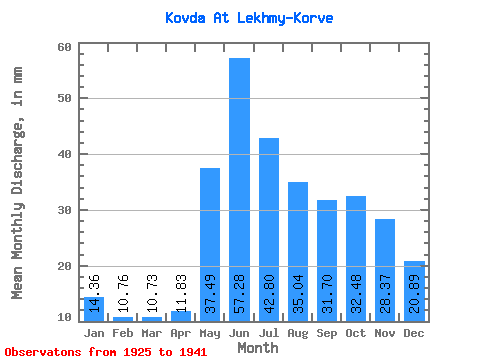
| Statistic | Jan | Feb | Mar | Apr | May | Jun | Jul | Aug | Sep | Oct | Nov | Dec | Annual |
|---|---|---|---|---|---|---|---|---|---|---|---|---|---|
| Mean | 14.36 | 10.86 | 10.73 | 11.83 | 37.48 | 57.27 | 42.79 | 35.03 | 31.70 | 32.47 | 28.36 | 20.89 | 338.76 |
| Standard Deviation | 3.64 | 2.63 | 2.24 | 2.85 | 11.70 | 11.38 | 8.42 | 7.56 | 8.92 | 12.65 | 9.85 | 5.82 | 59.68 |
| Min | 10.04 | 7.81 | 7.65 | 7.08 | 14.46 | 42.25 | 28.79 | 18.48 | 15.81 | 21.29 | 17.37 | 11.92 | 252.09 |
| Max | 22.63 | 16.59 | 15.93 | 18.27 | 53.83 | 80.35 | 59.32 | 46.33 | 47.95 | 71.77 | 51.58 | 33.48 | 479.98 |
| Coefficient of Variation | 0.25 | 0.24 | 0.21 | 0.24 | 0.31 | 0.20 | 0.20 | 0.22 | 0.28 | 0.39 | 0.35 | 0.28 | 0.18 |
 Return to R-Arctic Net Home Page