|
|
|||||||||||||||||
| Point ID: 9046 | Downloads | Plots | Site Data | Code: 49002 |
|
|
|||||||||||||||||
| Download | |
|---|---|
| Site Descriptor Information | Site Time Series Data |
| Link to all available data | |
| View: | Time Series | All |
| Units: | mm |
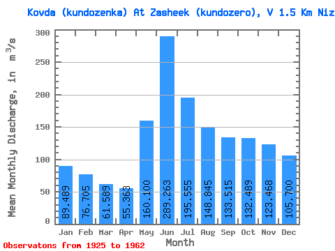
| Statistic | Jan | Feb | Mar | Apr | May | Jun | Jul | Aug | Sep | Oct | Nov | Dec | Annual |
|---|---|---|---|---|---|---|---|---|---|---|---|---|---|
| Mean | 89.49 | 76.70 | 61.59 | 55.36 | 160.10 | 289.26 | 195.56 | 148.84 | 133.51 | 132.49 | 123.47 | 105.70 | 131.59 |
| Standard Deviation | 37.40 | 29.93 | 18.73 | 14.83 | 53.48 | 68.21 | 50.95 | 46.73 | 49.66 | 70.39 | 52.58 | 36.87 | 28.42 |
| Min | 45.90 | 41.80 | 35.50 | 35.00 | 85.80 | 130.00 | 90.10 | 51.50 | 40.10 | 57.00 | 60.00 | 56.00 | 67.73 |
| Max | 188.00 | 162.00 | 102.00 | 86.80 | 251.00 | 401.00 | 279.00 | 234.00 | 222.00 | 353.00 | 277.00 | 184.00 | 197.58 |
| Coefficient of Variation | 0.42 | 0.39 | 0.30 | 0.27 | 0.33 | 0.24 | 0.26 | 0.31 | 0.37 | 0.53 | 0.43 | 0.35 | 0.22 |
 Return to R-Arctic Net Home Page