|
|
|||||||||||||||||
| Point ID: 9046 | Downloads | Plots | Site Data | Code: 49002 |
|
|
|||||||||||||||||
| Download | |
|---|---|
| Site Descriptor Information | Site Time Series Data |
| Link to all available data | |
| View: | Time Series | All |
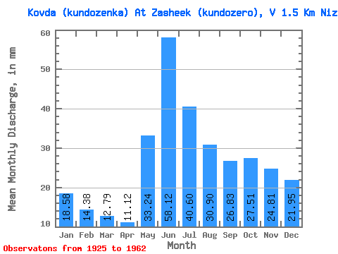
| Units: | m3/s |
| Statistic | Jan | Feb | Mar | Apr | May | Jun | Jul | Aug | Sep | Oct | Nov | Dec | Annual |
|---|---|---|---|---|---|---|---|---|---|---|---|---|---|
| Mean | 18.58 | 14.51 | 12.79 | 11.12 | 33.24 | 58.12 | 40.60 | 30.90 | 26.83 | 27.50 | 24.81 | 21.94 | 321.95 |
| Standard Deviation | 7.76 | 5.66 | 3.89 | 2.98 | 11.10 | 13.71 | 10.58 | 9.70 | 9.98 | 14.61 | 10.56 | 7.65 | 69.52 |
| Min | 9.53 | 7.91 | 7.37 | 7.03 | 17.81 | 26.12 | 18.70 | 10.69 | 8.06 | 11.83 | 12.06 | 11.62 | 165.71 |
| Max | 39.03 | 30.64 | 21.18 | 17.44 | 52.11 | 80.57 | 57.92 | 48.58 | 44.61 | 73.28 | 55.66 | 38.20 | 483.39 |
| Coefficient of Variation | 0.42 | 0.39 | 0.30 | 0.27 | 0.33 | 0.24 | 0.26 | 0.31 | 0.37 | 0.53 | 0.43 | 0.35 | 0.22 |
 Return to R-Arctic Net Home Page