|
|
|||||||||||||||||
| Point ID: 904 | Downloads | Plots | Site Data | Code: 07FD016 |
|
|
|||||||||||||||||
| Download | |
|---|---|
| Site Descriptor Information | Site Time Series Data |
| Link to all available data | |
| View: | Time Series | All |
| Units: | mm |
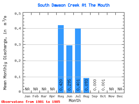
| Statistic | Jan | Feb | Mar | Apr | May | Jun | Jul | Aug | Sep | Oct | Nov | Dec | Annual |
|---|---|---|---|---|---|---|---|---|---|---|---|---|---|
| Mean | 0.42 | 0.29 | 0.40 | 0.09 | 0.00 | 0.00 | |||||||
| Standard Deviation | 0.29 | 0.43 | 0.85 | 0.20 | 0.00 | 0.00 | |||||||
| Min | 0.08 | 0.00 | 0.00 | 0.00 | 0.00 | 0.00 | |||||||
| Max | 0.74 | 1.04 | 1.92 | 0.46 | 0.00 | 0.00 | |||||||
| Coefficient of Variation | 0.69 | 1.46 | 2.12 | 2.18 | 1.37 | 1.73 |
 Return to R-Arctic Net Home Page