|
|
|||||||||||||||||
| Point ID: 904 | Downloads | Plots | Site Data | Code: 07FD016 |
|
|
|||||||||||||||||
| Download | |
|---|---|
| Site Descriptor Information | Site Time Series Data |
| Link to all available data | |
| View: | Time Series | All |
| Units: | m3/s |
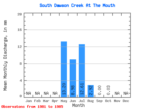
| Statistic | Jan | Feb | Mar | Apr | May | Jun | Jul | Aug | Sep | Oct | Nov | Dec | Annual |
|---|---|---|---|---|---|---|---|---|---|---|---|---|---|
| Mean | 13.22 | 8.98 | 12.61 | 2.93 | 0.01 | 0.02 | |||||||
| Standard Deviation | 9.13 | 13.14 | 26.71 | 6.39 | 0.02 | 0.04 | |||||||
| Min | 2.42 | 0.06 | 0.00 | 0.00 | 0.00 | 0.00 | |||||||
| Max | 23.39 | 31.64 | 60.36 | 14.37 | 0.03 | 0.06 | |||||||
| Coefficient of Variation | 0.69 | 1.46 | 2.12 | 2.18 | 1.37 | 1.73 |
 Return to R-Arctic Net Home Page