|
|
|||||||||||||||||
| Point ID: 9034 | Downloads | Plots | Site Data | Code: 71253 |
|
|
|||||||||||||||||
| Download | |
|---|---|
| Site Descriptor Information | Site Time Series Data |
| Link to all available data | |
| View: | Time Series | All |
| Units: | mm |
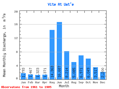
| Statistic | Jan | Feb | Mar | Apr | May | Jun | Jul | Aug | Sep | Oct | Nov | Dec | Annual |
|---|---|---|---|---|---|---|---|---|---|---|---|---|---|
| Mean | 1.79 | 1.47 | 1.32 | 1.37 | 14.36 | 16.69 | 8.21 | 5.08 | 6.97 | 6.05 | 3.52 | 2.20 | 5.70 |
| Standard Deviation | 0.49 | 0.49 | 0.48 | 0.43 | 5.76 | 5.42 | 3.91 | 1.52 | 2.11 | 2.30 | 1.01 | 0.53 | 0.53 |
| Min | 1.20 | 0.97 | 0.98 | 0.87 | 4.27 | 7.52 | 3.65 | 3.24 | 4.53 | 3.40 | 2.15 | 1.53 | 4.84 |
| Max | 2.99 | 2.83 | 2.75 | 2.45 | 26.00 | 25.40 | 16.90 | 8.56 | 12.10 | 11.90 | 5.49 | 3.28 | 6.47 |
| Coefficient of Variation | 0.28 | 0.33 | 0.37 | 0.31 | 0.40 | 0.33 | 0.48 | 0.30 | 0.30 | 0.38 | 0.29 | 0.24 | 0.09 |
 Return to R-Arctic Net Home Page