|
|
|||||||||||||||||
| Point ID: 9034 | Downloads | Plots | Site Data | Code: 71253 |
|
|
|||||||||||||||||
| Download | |
|---|---|
| Site Descriptor Information | Site Time Series Data |
| Link to all available data | |
| View: | Time Series | All |
| Units: | m3/s |
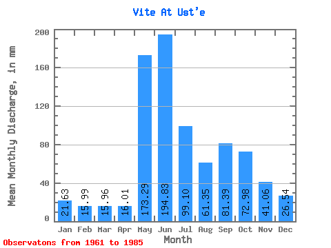
| Statistic | Jan | Feb | Mar | Apr | May | Jun | Jul | Aug | Sep | Oct | Nov | Dec | Annual |
|---|---|---|---|---|---|---|---|---|---|---|---|---|---|
| Mean | 21.63 | 16.13 | 15.96 | 16.00 | 173.26 | 194.83 | 99.08 | 61.34 | 81.39 | 72.97 | 41.06 | 26.54 | 809.91 |
| Standard Deviation | 5.96 | 5.35 | 5.84 | 4.97 | 69.45 | 63.27 | 47.18 | 18.38 | 24.59 | 27.79 | 11.81 | 6.39 | 74.99 |
| Min | 14.48 | 10.66 | 11.82 | 10.16 | 51.51 | 87.80 | 44.03 | 39.08 | 52.89 | 41.01 | 25.10 | 18.46 | 688.07 |
| Max | 36.07 | 31.11 | 33.17 | 28.61 | 313.64 | 296.56 | 203.87 | 103.26 | 141.28 | 143.55 | 64.10 | 39.57 | 920.26 |
| Coefficient of Variation | 0.28 | 0.33 | 0.37 | 0.31 | 0.40 | 0.33 | 0.48 | 0.30 | 0.30 | 0.38 | 0.29 | 0.24 | 0.09 |
 Return to R-Arctic Net Home Page