|
|
|||||||||||||||||
| Point ID: 9029 | Downloads | Plots | Site Data | Code: 71237 |
|
|
|||||||||||||||||
| Download | |
|---|---|
| Site Descriptor Information | Site Time Series Data |
| Link to all available data | |
| View: | Time Series | All |
| Units: | mm |
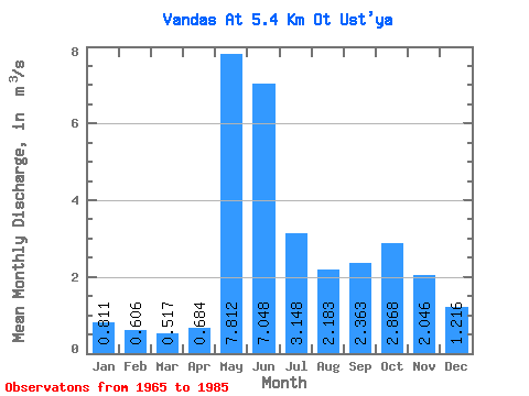
| Statistic | Jan | Feb | Mar | Apr | May | Jun | Jul | Aug | Sep | Oct | Nov | Dec | Annual |
|---|---|---|---|---|---|---|---|---|---|---|---|---|---|
| Mean | 0.81 | 0.61 | 0.52 | 0.68 | 7.81 | 7.05 | 3.15 | 2.18 | 2.36 | 2.87 | 2.05 | 1.22 | 2.57 |
| Standard Deviation | 0.24 | 0.18 | 0.14 | 0.36 | 3.23 | 2.18 | 1.89 | 1.37 | 1.16 | 1.26 | 1.05 | 0.43 | 0.51 |
| Min | 0.46 | 0.28 | 0.25 | 0.34 | 2.81 | 3.13 | 1.22 | 0.46 | 0.66 | 0.69 | 0.66 | 0.62 | 1.57 |
| Max | 1.29 | 1.01 | 0.76 | 1.55 | 14.30 | 11.90 | 7.58 | 5.28 | 5.55 | 4.92 | 5.36 | 2.38 | 3.32 |
| Coefficient of Variation | 0.30 | 0.29 | 0.28 | 0.52 | 0.41 | 0.31 | 0.60 | 0.63 | 0.49 | 0.44 | 0.52 | 0.35 | 0.20 |
 Return to R-Arctic Net Home Page