|
|
|||||||||||||||||
| Point ID: 9029 | Downloads | Plots | Site Data | Code: 71237 |
|
|
|||||||||||||||||
| Download | |
|---|---|
| Site Descriptor Information | Site Time Series Data |
| Link to all available data | |
| View: | Time Series | All |
| Units: | m3/s |
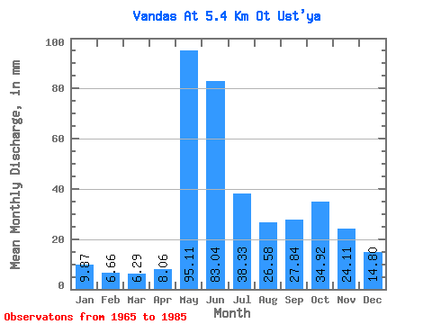
| Statistic | Jan | Feb | Mar | Apr | May | Jun | Jul | Aug | Sep | Oct | Nov | Dec | Annual |
|---|---|---|---|---|---|---|---|---|---|---|---|---|---|
| Mean | 9.87 | 6.72 | 6.29 | 8.06 | 95.09 | 83.04 | 38.33 | 26.57 | 27.84 | 34.91 | 24.11 | 14.80 | 368.99 |
| Standard Deviation | 2.92 | 1.96 | 1.74 | 4.22 | 39.27 | 25.70 | 23.00 | 16.64 | 13.70 | 15.34 | 12.43 | 5.20 | 73.31 |
| Min | 5.60 | 3.10 | 3.04 | 4.01 | 34.20 | 36.88 | 14.85 | 5.60 | 7.78 | 8.40 | 7.78 | 7.55 | 225.70 |
| Max | 15.70 | 11.20 | 9.25 | 18.26 | 174.07 | 140.20 | 92.27 | 64.27 | 65.39 | 59.89 | 63.15 | 28.97 | 476.87 |
| Coefficient of Variation | 0.30 | 0.29 | 0.28 | 0.52 | 0.41 | 0.31 | 0.60 | 0.63 | 0.49 | 0.44 | 0.52 | 0.35 | 0.20 |
 Return to R-Arctic Net Home Page