|
|
|||||||||||||||||
| Point ID: 9017 | Downloads | Plots | Site Data | Code: 71203 |
|
|
|||||||||||||||||
| Download | |
|---|---|
| Site Descriptor Information | Site Time Series Data |
| Link to all available data | |
| View: | Time Series | All |
| Units: | mm |
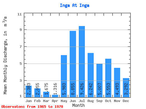
| Statistic | Jan | Feb | Mar | Apr | May | Jun | Jul | Aug | Sep | Oct | Nov | Dec | Annual |
|---|---|---|---|---|---|---|---|---|---|---|---|---|---|
| Mean | 2.38 | 2.06 | 1.68 | 1.32 | 5.98 | 8.86 | 9.43 | 6.24 | 5.01 | 5.55 | 4.49 | 3.29 | 4.78 |
| Standard Deviation | 1.10 | 0.88 | 0.76 | 0.59 | 3.59 | 2.65 | 2.81 | 1.93 | 1.26 | 2.66 | 2.70 | 1.73 | 1.07 |
| Min | 0.78 | 0.93 | 0.78 | 0.69 | 1.70 | 3.84 | 3.21 | 2.86 | 3.48 | 1.56 | 0.96 | 0.82 | 3.29 |
| Max | 4.68 | 3.79 | 3.56 | 2.59 | 12.30 | 13.80 | 13.00 | 9.02 | 8.15 | 10.40 | 9.70 | 6.38 | 6.60 |
| Coefficient of Variation | 0.46 | 0.43 | 0.45 | 0.45 | 0.60 | 0.30 | 0.30 | 0.31 | 0.25 | 0.48 | 0.60 | 0.53 | 0.22 |
 Return to R-Arctic Net Home Page