|
|
|||||||||||||||||
| Point ID: 9017 | Downloads | Plots | Site Data | Code: 71203 |
|
|
|||||||||||||||||
| Download | |
|---|---|
| Site Descriptor Information | Site Time Series Data |
| Link to all available data | |
| View: | Time Series | All |
| Units: | m3/s |
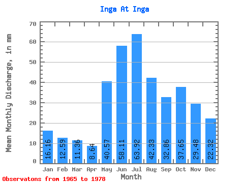
| Statistic | Jan | Feb | Mar | Apr | May | Jun | Jul | Aug | Sep | Oct | Nov | Dec | Annual |
|---|---|---|---|---|---|---|---|---|---|---|---|---|---|
| Mean | 16.16 | 12.70 | 11.35 | 8.64 | 40.56 | 58.11 | 63.91 | 42.32 | 32.86 | 37.65 | 29.48 | 22.32 | 381.95 |
| Standard Deviation | 7.48 | 5.43 | 5.13 | 3.85 | 24.34 | 17.41 | 19.09 | 13.12 | 8.28 | 18.05 | 17.72 | 11.72 | 85.52 |
| Min | 5.29 | 5.75 | 5.29 | 4.53 | 11.53 | 25.20 | 21.76 | 19.39 | 22.84 | 10.58 | 6.30 | 5.56 | 263.13 |
| Max | 31.73 | 23.41 | 24.14 | 17.00 | 83.39 | 90.56 | 88.14 | 61.15 | 53.48 | 70.51 | 63.65 | 43.26 | 527.47 |
| Coefficient of Variation | 0.46 | 0.43 | 0.45 | 0.45 | 0.60 | 0.30 | 0.30 | 0.31 | 0.25 | 0.48 | 0.60 | 0.53 | 0.22 |
 Return to R-Arctic Net Home Page