|
|
|||||||||||||||||
| Point ID: 9015 | Downloads | Plots | Site Data | Code: 71198 |
|
|
|||||||||||||||||
| Download | |
|---|---|
| Site Descriptor Information | Site Time Series Data |
| Link to all available data | |
| View: | Time Series | All |
| Units: | mm |
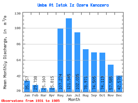
| Statistic | Jan | Feb | Mar | Apr | May | Jun | Jul | Aug | Sep | Oct | Nov | Dec | Annual |
|---|---|---|---|---|---|---|---|---|---|---|---|---|---|
| Mean | 35.76 | 29.74 | 25.16 | 25.82 | 107.27 | 121.55 | 102.03 | 78.97 | 74.50 | 74.12 | 57.59 | 42.57 | 64.52 |
| Standard Deviation | 7.69 | 6.53 | 5.46 | 7.34 | 41.98 | 33.94 | 27.55 | 22.23 | 23.39 | 25.97 | 18.39 | 9.52 | 12.73 |
| Min | 17.70 | 15.40 | 13.00 | 14.00 | 41.60 | 57.30 | 38.50 | 34.00 | 34.50 | 27.00 | 20.00 | 19.30 | 34.61 |
| Max | 53.30 | 45.10 | 39.10 | 51.50 | 203.00 | 204.00 | 164.00 | 128.00 | 139.00 | 173.00 | 102.00 | 67.20 | 95.78 |
| Coefficient of Variation | 0.21 | 0.22 | 0.22 | 0.28 | 0.39 | 0.28 | 0.27 | 0.28 | 0.31 | 0.35 | 0.32 | 0.22 | 0.20 |
 Return to R-Arctic Net Home Page