|
|
|||||||||||||||||
| Point ID: 9015 | Downloads | Plots | Site Data | Code: 71198 |
|
|
|||||||||||||||||
| Download | |
|---|---|
| Site Descriptor Information | Site Time Series Data |
| Link to all available data | |
| View: | Time Series | All |
| Units: | m3/s |
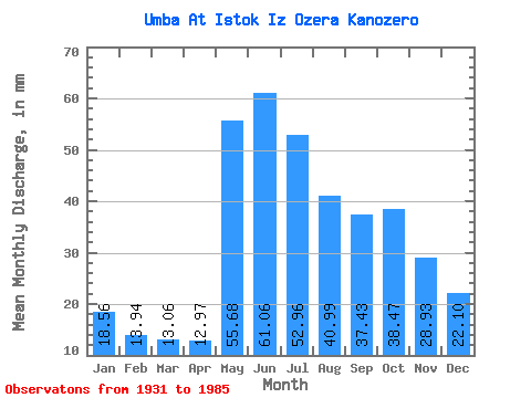
| Statistic | Jan | Feb | Mar | Apr | May | Jun | Jul | Aug | Sep | Oct | Nov | Dec | Annual |
|---|---|---|---|---|---|---|---|---|---|---|---|---|---|
| Mean | 18.56 | 14.06 | 13.06 | 12.97 | 55.67 | 61.05 | 52.95 | 40.98 | 37.43 | 38.47 | 28.93 | 22.09 | 394.63 |
| Standard Deviation | 3.99 | 3.09 | 2.83 | 3.69 | 21.79 | 17.05 | 14.30 | 11.54 | 11.75 | 13.48 | 9.24 | 4.94 | 77.86 |
| Min | 9.19 | 7.28 | 6.75 | 7.03 | 21.59 | 28.78 | 19.98 | 17.65 | 17.33 | 14.01 | 10.05 | 10.02 | 211.67 |
| Max | 27.66 | 21.33 | 20.29 | 25.87 | 105.36 | 102.47 | 85.11 | 66.43 | 69.82 | 89.79 | 51.24 | 34.88 | 585.79 |
| Coefficient of Variation | 0.21 | 0.22 | 0.22 | 0.28 | 0.39 | 0.28 | 0.27 | 0.28 | 0.31 | 0.35 | 0.32 | 0.22 | 0.20 |
 Return to R-Arctic Net Home Page