|
|
|||||||||||||||||
| Point ID: 9012 | Downloads | Plots | Site Data | Code: 71184 |
|
|
|||||||||||||||||
| Download | |
|---|---|
| Site Descriptor Information | Site Time Series Data |
| Link to all available data | |
| View: | Time Series | All |
| Units: | mm |
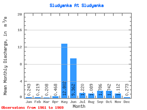
| Statistic | Jan | Feb | Mar | Apr | May | Jun | Jul | Aug | Sep | Oct | Nov | Dec | Annual |
|---|---|---|---|---|---|---|---|---|---|---|---|---|---|
| Mean | 0.24 | 0.22 | 0.21 | 0.47 | 12.80 | 9.36 | 1.22 | 1.09 | 1.79 | 1.74 | 1.11 | 0.27 | 1.63 |
| Standard Deviation | 0.24 | 0.30 | 0.31 | 0.44 | 14.57 | 17.86 | 0.82 | 1.39 | 0.84 | 0.56 | 0.68 | 0.07 | 0.35 |
| Min | 0.13 | 0.09 | 0.09 | 0.09 | 1.48 | 1.35 | 0.39 | 0.24 | 0.59 | 0.87 | 0.31 | 0.20 | 1.31 |
| Max | 0.87 | 1.02 | 1.04 | 1.26 | 50.70 | 56.70 | 2.78 | 4.33 | 2.92 | 2.43 | 2.24 | 0.40 | 2.30 |
| Coefficient of Variation | 0.97 | 1.38 | 1.50 | 0.95 | 1.14 | 1.91 | 0.67 | 1.27 | 0.47 | 0.32 | 0.61 | 0.24 | 0.21 |
 Return to R-Arctic Net Home Page