|
|
|||||||||||||||||
| Point ID: 9012 | Downloads | Plots | Site Data | Code: 71184 |
|
|
|||||||||||||||||
| Download | |
|---|---|
| Site Descriptor Information | Site Time Series Data |
| Link to all available data | |
| View: | Time Series | All |
| Units: | m3/s |
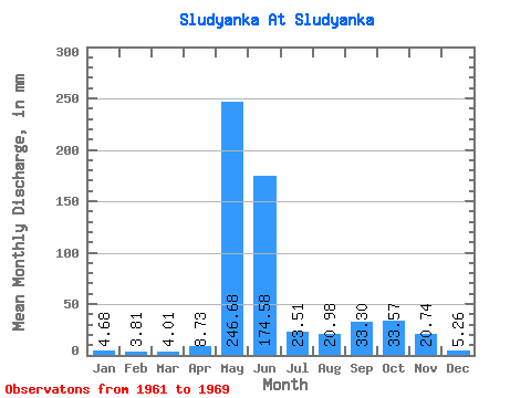
| Statistic | Jan | Feb | Mar | Apr | May | Jun | Jul | Aug | Sep | Oct | Nov | Dec | Annual |
|---|---|---|---|---|---|---|---|---|---|---|---|---|---|
| Mean | 4.69 | 3.85 | 4.01 | 8.72 | 246.65 | 174.58 | 23.50 | 20.98 | 33.31 | 33.57 | 20.74 | 5.27 | 370.44 |
| Standard Deviation | 4.55 | 5.30 | 6.01 | 8.27 | 280.80 | 333.13 | 15.76 | 26.73 | 15.73 | 10.76 | 12.76 | 1.29 | 78.90 |
| Min | 2.50 | 1.60 | 1.79 | 1.62 | 28.51 | 25.17 | 7.51 | 4.62 | 11.00 | 16.76 | 5.78 | 3.85 | 297.62 |
| Max | 16.77 | 17.91 | 20.04 | 23.50 | 976.80 | 1057.31 | 53.56 | 83.42 | 54.45 | 46.82 | 41.77 | 7.71 | 522.97 |
| Coefficient of Variation | 0.97 | 1.38 | 1.50 | 0.95 | 1.14 | 1.91 | 0.67 | 1.27 | 0.47 | 0.32 | 0.61 | 0.24 | 0.21 |
 Return to R-Arctic Net Home Page