|
|
|||||||||||||||||
| Point ID: 9003 | Downloads | Plots | Site Data | Code: 71155 |
|
|
|||||||||||||||||
| Download | |
|---|---|
| Site Descriptor Information | Site Time Series Data |
| Link to all available data | |
| View: | Time Series | All |
| Units: | mm |
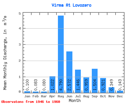
| Statistic | Jan | Feb | Mar | Apr | May | Jun | Jul | Aug | Sep | Oct | Nov | Dec | Annual |
|---|---|---|---|---|---|---|---|---|---|---|---|---|---|
| Mean | 0.10 | 0.08 | 0.08 | 1.02 | 4.79 | 2.57 | 1.45 | 0.96 | 1.50 | 0.92 | 0.35 | 0.14 | 1.17 |
| Standard Deviation | 0.04 | 0.04 | 0.03 | 1.18 | 2.30 | 1.94 | 1.35 | 0.56 | 1.02 | 0.45 | 0.21 | 0.06 | 0.38 |
| Min | 0.02 | 0.00 | 0.02 | 0.04 | 0.95 | 0.64 | 0.19 | 0.16 | 0.64 | 0.29 | 0.08 | 0.02 | 0.37 |
| Max | 0.15 | 0.14 | 0.14 | 3.79 | 8.33 | 7.73 | 4.49 | 1.87 | 4.02 | 1.62 | 0.90 | 0.23 | 1.98 |
| Coefficient of Variation | 0.42 | 0.48 | 0.41 | 1.15 | 0.48 | 0.76 | 0.93 | 0.59 | 0.68 | 0.49 | 0.61 | 0.45 | 0.33 |
 Return to R-Arctic Net Home Page