|
|
|||||||||||||||||
| Point ID: 9003 | Downloads | Plots | Site Data | Code: 71155 |
|
|
|||||||||||||||||
| Download | |
|---|---|
| Site Descriptor Information | Site Time Series Data |
| Link to all available data | |
| View: | Time Series | All |
| Units: | m3/s |
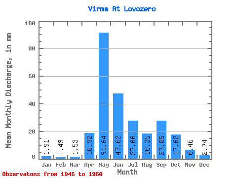
| Statistic | Jan | Feb | Mar | Apr | May | Jun | Jul | Aug | Sep | Oct | Nov | Dec | Annual |
|---|---|---|---|---|---|---|---|---|---|---|---|---|---|
| Mean | 1.91 | 1.44 | 1.54 | 18.92 | 91.63 | 47.62 | 27.65 | 18.34 | 27.84 | 17.61 | 6.46 | 2.73 | 262.98 |
| Standard Deviation | 0.81 | 0.69 | 0.64 | 21.81 | 43.94 | 35.93 | 25.76 | 10.81 | 18.88 | 8.63 | 3.94 | 1.22 | 86.38 |
| Min | 0.32 | 0.00 | 0.46 | 0.78 | 18.17 | 11.85 | 3.63 | 3.06 | 11.85 | 5.55 | 1.54 | 0.31 | 84.25 |
| Max | 2.87 | 2.44 | 2.68 | 70.17 | 159.34 | 143.12 | 85.89 | 35.77 | 74.43 | 30.99 | 16.66 | 4.40 | 446.91 |
| Coefficient of Variation | 0.42 | 0.48 | 0.41 | 1.15 | 0.48 | 0.76 | 0.93 | 0.59 | 0.68 | 0.49 | 0.61 | 0.45 | 0.33 |
 Return to R-Arctic Net Home Page