|
|
|||||||||||||||||
| Point ID: 90 | Downloads | Plots | Site Data | Code: 05AD010 |
|
|
|||||||||||||||||
| Download | |
|---|---|
| Site Descriptor Information | Site Time Series Data |
| Link to all available data | |
| View: | Time Series | All |
| Units: | mm |
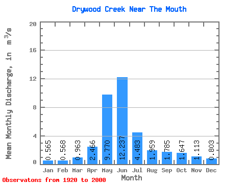
| Statistic | Jan | Feb | Mar | Apr | May | Jun | Jul | Aug | Sep | Oct | Nov | Dec | Annual |
|---|---|---|---|---|---|---|---|---|---|---|---|---|---|
| Mean | 0.56 | 0.57 | 0.96 | 2.47 | 9.77 | 12.24 | 4.48 | 1.96 | 1.79 | 1.65 | 1.11 | 0.80 | 2.93 |
| Standard Deviation | 0.31 | 0.43 | 0.86 | 1.29 | 4.20 | 8.02 | 2.84 | 1.23 | 1.63 | 1.21 | 0.70 | 0.59 | 1.14 |
| Min | 0.24 | 0.20 | 0.26 | 0.52 | 2.83 | 2.26 | 0.76 | 0.55 | 0.51 | 0.43 | 0.34 | 0.30 | 1.14 |
| Max | 1.64 | 2.32 | 4.84 | 5.96 | 19.70 | 35.80 | 11.90 | 4.91 | 6.65 | 5.19 | 2.63 | 2.63 | 6.27 |
| Coefficient of Variation | 0.56 | 0.75 | 0.89 | 0.52 | 0.43 | 0.66 | 0.64 | 0.63 | 0.91 | 0.73 | 0.63 | 0.74 | 0.39 |
 Return to R-Arctic Net Home Page