|
|
|||||||||||||||||
| Point ID: 90 | Downloads | Plots | Site Data | Code: 05AD010 |
|
|
|||||||||||||||||
| Download | |
|---|---|
| Site Descriptor Information | Site Time Series Data |
| Link to all available data | |
| View: | Time Series | All |
| Units: | m3/s |
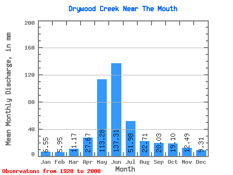
| Statistic | Jan | Feb | Mar | Apr | May | Jun | Jul | Aug | Sep | Oct | Nov | Dec | Annual |
|---|---|---|---|---|---|---|---|---|---|---|---|---|---|
| Mean | 6.36 | 5.82 | 10.84 | 26.86 | 109.93 | 133.27 | 50.44 | 22.04 | 19.44 | 18.54 | 12.12 | 9.04 | 388.39 |
| Standard Deviation | 3.53 | 4.38 | 9.68 | 14.06 | 47.20 | 87.34 | 32.01 | 13.79 | 17.73 | 13.58 | 7.61 | 6.65 | 151.17 |
| Min | 2.67 | 2.01 | 2.87 | 5.70 | 31.84 | 24.61 | 8.60 | 6.18 | 5.54 | 4.86 | 3.65 | 3.34 | 151.27 |
| Max | 18.45 | 23.79 | 54.46 | 64.91 | 221.67 | 389.89 | 133.90 | 55.25 | 72.42 | 58.40 | 28.64 | 29.59 | 831.10 |
| Coefficient of Variation | 0.56 | 0.75 | 0.89 | 0.52 | 0.43 | 0.66 | 0.64 | 0.63 | 0.91 | 0.73 | 0.63 | 0.74 | 0.39 |
 Return to R-Arctic Net Home Page