|
|
|||||||||||||||||
| Point ID: 8997 | Downloads | Plots | Site Data | Code: 71146 |
|
|
|||||||||||||||||
| Download | |
|---|---|
| Site Descriptor Information | Site Time Series Data |
| Link to all available data | |
| View: | Time Series | All |
| Units: | mm |
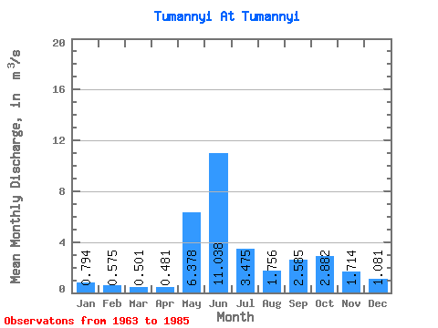
| Statistic | Jan | Feb | Mar | Apr | May | Jun | Jul | Aug | Sep | Oct | Nov | Dec | Annual |
|---|---|---|---|---|---|---|---|---|---|---|---|---|---|
| Mean | 0.79 | 0.57 | 0.50 | 0.48 | 6.38 | 11.04 | 3.48 | 1.76 | 2.58 | 2.88 | 1.71 | 1.08 | 2.79 |
| Standard Deviation | 0.13 | 0.10 | 0.11 | 0.16 | 4.44 | 3.09 | 2.25 | 0.78 | 0.84 | 1.12 | 0.56 | 0.30 | 0.55 |
| Min | 0.60 | 0.42 | 0.34 | 0.30 | 0.76 | 6.55 | 1.11 | 0.68 | 1.34 | 1.31 | 1.12 | 0.74 | 1.92 |
| Max | 1.05 | 0.76 | 0.76 | 0.95 | 15.50 | 16.20 | 8.46 | 3.04 | 5.15 | 5.08 | 2.95 | 1.87 | 3.52 |
| Coefficient of Variation | 0.17 | 0.17 | 0.22 | 0.33 | 0.70 | 0.28 | 0.65 | 0.45 | 0.32 | 0.39 | 0.33 | 0.28 | 0.20 |
 Return to R-Arctic Net Home Page