|
|
|||||||||||||||||
| Point ID: 8997 | Downloads | Plots | Site Data | Code: 71146 |
|
|
|||||||||||||||||
| Download | |
|---|---|
| Site Descriptor Information | Site Time Series Data |
| Link to all available data | |
| View: | Time Series | All |
| Units: | m3/s |
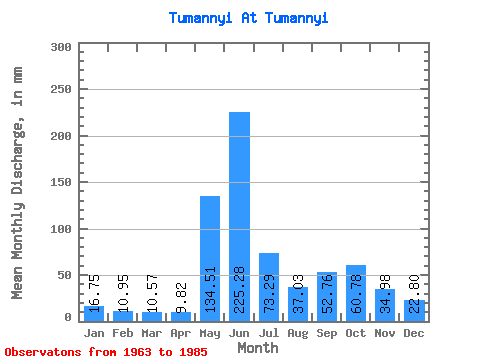
| Statistic | Jan | Feb | Mar | Apr | May | Jun | Jul | Aug | Sep | Oct | Nov | Dec | Annual |
|---|---|---|---|---|---|---|---|---|---|---|---|---|---|
| Mean | 16.75 | 11.04 | 10.56 | 9.81 | 134.48 | 225.29 | 73.28 | 37.03 | 52.75 | 60.77 | 34.98 | 22.80 | 693.92 |
| Standard Deviation | 2.80 | 1.90 | 2.36 | 3.21 | 93.57 | 63.12 | 47.55 | 16.46 | 17.09 | 23.65 | 11.40 | 6.26 | 135.76 |
| Min | 12.65 | 8.07 | 7.17 | 6.12 | 16.03 | 133.68 | 23.41 | 14.34 | 27.35 | 27.62 | 22.86 | 15.60 | 476.51 |
| Max | 22.14 | 14.60 | 16.03 | 19.39 | 326.84 | 330.63 | 178.39 | 64.10 | 105.11 | 107.12 | 60.21 | 39.43 | 873.70 |
| Coefficient of Variation | 0.17 | 0.17 | 0.22 | 0.33 | 0.70 | 0.28 | 0.65 | 0.45 | 0.32 | 0.39 | 0.33 | 0.28 | 0.20 |
 Return to R-Arctic Net Home Page