|
|
|||||||||||||||||
| Point ID: 8989 | Downloads | Plots | Site Data | Code: 71132 |
|
|
|||||||||||||||||
| Download | |
|---|---|
| Site Descriptor Information | Site Time Series Data |
| Link to all available data | |
| View: | Time Series | All |
| Units: | mm |
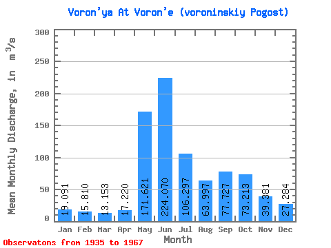
| Statistic | Jan | Feb | Mar | Apr | May | Jun | Jul | Aug | Sep | Oct | Nov | Dec | Annual |
|---|---|---|---|---|---|---|---|---|---|---|---|---|---|
| Mean | 19.09 | 15.81 | 13.15 | 17.22 | 171.62 | 224.07 | 106.30 | 64.00 | 77.73 | 73.21 | 39.38 | 27.28 | 71.39 |
| Standard Deviation | 4.56 | 3.33 | 2.54 | 11.08 | 81.38 | 90.58 | 46.30 | 27.54 | 30.77 | 29.40 | 12.71 | 8.00 | 15.11 |
| Min | 12.10 | 9.43 | 8.04 | 9.12 | 36.00 | 61.80 | 30.80 | 19.90 | 35.50 | 27.60 | 17.20 | 12.80 | 32.34 |
| Max | 29.10 | 22.90 | 17.60 | 58.40 | 346.00 | 403.00 | 232.00 | 121.00 | 139.00 | 125.00 | 61.90 | 42.00 | 105.42 |
| Coefficient of Variation | 0.24 | 0.21 | 0.19 | 0.64 | 0.47 | 0.40 | 0.44 | 0.43 | 0.40 | 0.40 | 0.32 | 0.29 | 0.21 |
 Return to R-Arctic Net Home Page