|
|
|||||||||||||||||
| Point ID: 8989 | Downloads | Plots | Site Data | Code: 71132 |
|
|
|||||||||||||||||
| Download | |
|---|---|
| Site Descriptor Information | Site Time Series Data |
| Link to all available data | |
| View: | Time Series | All |
| Units: | m3/s |
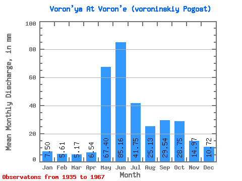
| Statistic | Jan | Feb | Mar | Apr | May | Jun | Jul | Aug | Sep | Oct | Nov | Dec | Annual |
|---|---|---|---|---|---|---|---|---|---|---|---|---|---|
| Mean | 7.50 | 5.66 | 5.17 | 6.54 | 67.39 | 85.16 | 41.74 | 25.13 | 29.54 | 28.75 | 14.97 | 10.71 | 330.35 |
| Standard Deviation | 1.79 | 1.19 | 1.00 | 4.21 | 31.95 | 34.43 | 18.18 | 10.81 | 11.69 | 11.54 | 4.83 | 3.14 | 69.91 |
| Min | 4.75 | 3.37 | 3.16 | 3.47 | 14.14 | 23.49 | 12.09 | 7.81 | 13.49 | 10.84 | 6.54 | 5.03 | 149.66 |
| Max | 11.43 | 8.19 | 6.91 | 22.20 | 135.86 | 153.16 | 91.10 | 47.51 | 52.83 | 49.08 | 23.53 | 16.49 | 487.82 |
| Coefficient of Variation | 0.24 | 0.21 | 0.19 | 0.64 | 0.47 | 0.40 | 0.44 | 0.43 | 0.40 | 0.40 | 0.32 | 0.29 | 0.21 |
 Return to R-Arctic Net Home Page