|
|
|||||||||||||||||
| Point ID: 8962 | Downloads | Plots | Site Data | Code: 71046 |
|
|
|||||||||||||||||
| Download | |
|---|---|
| Site Descriptor Information | Site Time Series Data |
| Link to all available data | |
| View: | Time Series | All |
| Units: | mm |
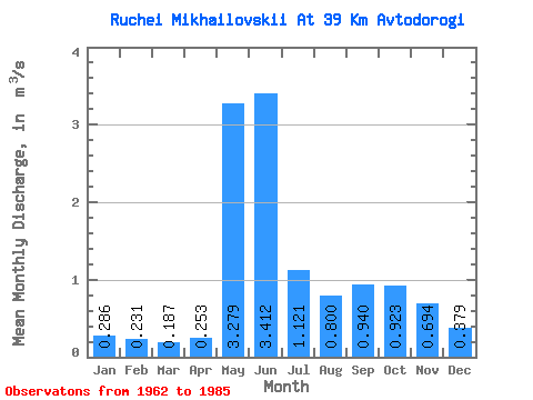
| Statistic | Jan | Feb | Mar | Apr | May | Jun | Jul | Aug | Sep | Oct | Nov | Dec | Annual |
|---|---|---|---|---|---|---|---|---|---|---|---|---|---|
| Mean | 0.29 | 0.23 | 0.19 | 0.25 | 3.28 | 3.41 | 1.12 | 0.80 | 0.94 | 0.92 | 0.69 | 0.38 | 1.05 |
| Standard Deviation | 0.08 | 0.07 | 0.06 | 0.20 | 1.74 | 1.47 | 0.59 | 0.47 | 0.55 | 0.24 | 0.40 | 0.10 | 0.23 |
| Min | 0.11 | 0.06 | 0.05 | 0.05 | 0.68 | 1.32 | 0.46 | 0.24 | 0.37 | 0.52 | 0.26 | 0.18 | 0.61 |
| Max | 0.41 | 0.37 | 0.32 | 1.07 | 7.06 | 6.23 | 2.58 | 2.27 | 3.04 | 1.34 | 2.12 | 0.58 | 1.54 |
| Coefficient of Variation | 0.28 | 0.30 | 0.32 | 0.81 | 0.53 | 0.43 | 0.53 | 0.59 | 0.59 | 0.26 | 0.58 | 0.26 | 0.22 |
 Return to R-Arctic Net Home Page