|
|
|||||||||||||||||
| Point ID: 8962 | Downloads | Plots | Site Data | Code: 71046 |
|
|
|||||||||||||||||
| Download | |
|---|---|
| Site Descriptor Information | Site Time Series Data |
| Link to all available data | |
| View: | Time Series | All |
| Units: | m3/s |
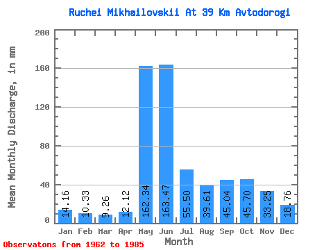
| Statistic | Jan | Feb | Mar | Apr | May | Jun | Jul | Aug | Sep | Oct | Nov | Dec | Annual |
|---|---|---|---|---|---|---|---|---|---|---|---|---|---|
| Mean | 14.14 | 10.41 | 9.26 | 12.13 | 162.30 | 163.47 | 55.51 | 39.62 | 45.04 | 45.67 | 33.26 | 18.77 | 612.95 |
| Standard Deviation | 4.01 | 3.12 | 2.92 | 9.80 | 86.33 | 70.47 | 29.44 | 23.27 | 26.45 | 11.97 | 19.36 | 4.87 | 135.07 |
| Min | 5.45 | 2.71 | 2.52 | 2.59 | 33.66 | 63.24 | 22.77 | 11.88 | 17.73 | 25.74 | 12.46 | 8.91 | 357.31 |
| Max | 20.30 | 16.69 | 15.84 | 51.27 | 349.48 | 298.49 | 127.71 | 112.37 | 145.68 | 66.33 | 101.60 | 28.71 | 896.92 |
| Coefficient of Variation | 0.28 | 0.30 | 0.32 | 0.81 | 0.53 | 0.43 | 0.53 | 0.59 | 0.59 | 0.26 | 0.58 | 0.26 | 0.22 |
 Return to R-Arctic Net Home Page