|
|
|||||||||||||||||
| Point ID: 8961 | Downloads | Plots | Site Data | Code: 71042 |
|
|
|||||||||||||||||
| Download | |
|---|---|
| Site Descriptor Information | Site Time Series Data |
| Link to all available data | |
| View: | Time Series | All |
| Units: | mm |
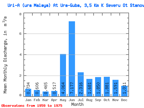
| Statistic | Jan | Feb | Mar | Apr | May | Jun | Jul | Aug | Sep | Oct | Nov | Dec | Annual |
|---|---|---|---|---|---|---|---|---|---|---|---|---|---|
| Mean | 0.73 | 0.61 | 0.47 | 0.52 | 4.06 | 7.18 | 2.32 | 1.68 | 1.85 | 1.88 | 1.59 | 1.01 | 1.99 |
| Standard Deviation | 0.22 | 0.15 | 0.10 | 0.34 | 2.92 | 2.99 | 0.88 | 1.25 | 1.33 | 0.88 | 0.69 | 0.33 | 0.49 |
| Min | 0.38 | 0.29 | 0.33 | 0.22 | 1.00 | 1.72 | 0.60 | 0.26 | 0.49 | 0.64 | 0.50 | 0.55 | 1.09 |
| Max | 1.09 | 0.83 | 0.65 | 1.64 | 11.00 | 12.60 | 4.02 | 4.93 | 5.48 | 4.50 | 3.40 | 1.61 | 2.75 |
| Coefficient of Variation | 0.30 | 0.25 | 0.21 | 0.66 | 0.72 | 0.42 | 0.38 | 0.74 | 0.72 | 0.47 | 0.43 | 0.33 | 0.25 |
 Return to R-Arctic Net Home Page