|
|
|||||||||||||||||
| Point ID: 8961 | Downloads | Plots | Site Data | Code: 71042 |
|
|
|||||||||||||||||
| Download | |
|---|---|
| Site Descriptor Information | Site Time Series Data |
| Link to all available data | |
| View: | Time Series | All |
| Units: | m3/s |
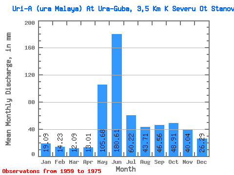
| Statistic | Jan | Feb | Mar | Apr | May | Jun | Jul | Aug | Sep | Oct | Nov | Dec | Annual |
|---|---|---|---|---|---|---|---|---|---|---|---|---|---|
| Mean | 19.09 | 14.35 | 12.09 | 13.02 | 105.66 | 180.61 | 60.23 | 43.71 | 46.55 | 48.90 | 40.03 | 26.29 | 608.52 |
| Standard Deviation | 5.67 | 3.58 | 2.56 | 8.65 | 75.97 | 75.32 | 22.83 | 32.52 | 33.51 | 22.90 | 17.24 | 8.57 | 150.49 |
| Min | 9.88 | 6.87 | 8.58 | 5.54 | 26.00 | 43.28 | 15.60 | 6.76 | 12.33 | 16.64 | 12.58 | 14.30 | 335.52 |
| Max | 28.34 | 19.66 | 16.90 | 41.27 | 286.00 | 317.08 | 104.52 | 128.18 | 137.90 | 117.00 | 85.56 | 41.86 | 844.15 |
| Coefficient of Variation | 0.30 | 0.25 | 0.21 | 0.66 | 0.72 | 0.42 | 0.38 | 0.74 | 0.72 | 0.47 | 0.43 | 0.33 | 0.25 |
 Return to R-Arctic Net Home Page