|
|
|||||||||||||||||
| Point ID: 8960 | Downloads | Plots | Site Data | Code: 71040 |
|
|
|||||||||||||||||
| Download | |
|---|---|
| Site Descriptor Information | Site Time Series Data |
| Link to all available data | |
| View: | Time Series | All |
| Units: | mm |
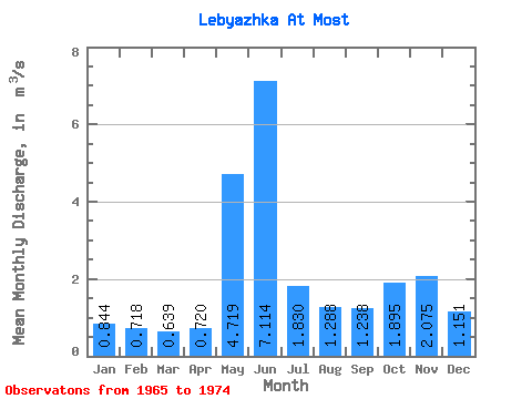
| Statistic | Jan | Feb | Mar | Apr | May | Jun | Jul | Aug | Sep | Oct | Nov | Dec | Annual |
|---|---|---|---|---|---|---|---|---|---|---|---|---|---|
| Mean | 0.84 | 0.72 | 0.64 | 0.72 | 4.72 | 7.11 | 1.83 | 1.29 | 1.24 | 1.90 | 2.08 | 1.15 | 2.08 |
| Standard Deviation | 0.24 | 0.16 | 0.13 | 0.34 | 2.80 | 3.17 | 0.27 | 0.54 | 0.20 | 0.49 | 1.16 | 0.28 | 0.37 |
| Min | 0.48 | 0.51 | 0.37 | 0.34 | 1.38 | 3.90 | 1.50 | 0.82 | 0.94 | 1.12 | 1.01 | 0.83 | 1.59 |
| Max | 1.24 | 1.06 | 0.87 | 1.52 | 9.28 | 13.60 | 2.19 | 2.21 | 1.40 | 2.42 | 4.78 | 1.64 | 2.49 |
| Coefficient of Variation | 0.28 | 0.22 | 0.21 | 0.47 | 0.59 | 0.45 | 0.15 | 0.42 | 0.16 | 0.26 | 0.56 | 0.24 | 0.18 |
 Return to R-Arctic Net Home Page