|
|
|||||||||||||||||
| Point ID: 8960 | Downloads | Plots | Site Data | Code: 71040 |
|
|
|||||||||||||||||
| Download | |
|---|---|
| Site Descriptor Information | Site Time Series Data |
| Link to all available data | |
| View: | Time Series | All |
| Units: | m3/s |
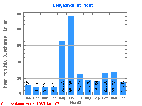
| Statistic | Jan | Feb | Mar | Apr | May | Jun | Jul | Aug | Sep | Oct | Nov | Dec | Annual |
|---|---|---|---|---|---|---|---|---|---|---|---|---|---|
| Mean | 11.65 | 9.03 | 8.82 | 9.62 | 65.14 | 95.05 | 25.26 | 17.78 | 16.54 | 26.16 | 27.72 | 15.89 | 337.51 |
| Standard Deviation | 3.27 | 1.97 | 1.85 | 4.49 | 38.68 | 42.31 | 3.73 | 7.51 | 2.63 | 6.74 | 15.56 | 3.86 | 60.19 |
| Min | 6.63 | 6.41 | 5.11 | 4.54 | 19.05 | 52.11 | 20.71 | 11.32 | 12.56 | 15.46 | 13.49 | 11.46 | 257.98 |
| Max | 17.12 | 13.33 | 12.01 | 20.31 | 128.10 | 181.71 | 30.23 | 30.51 | 18.70 | 33.41 | 63.87 | 22.64 | 404.40 |
| Coefficient of Variation | 0.28 | 0.22 | 0.21 | 0.47 | 0.59 | 0.45 | 0.15 | 0.42 | 0.16 | 0.26 | 0.56 | 0.24 | 0.18 |
 Return to R-Arctic Net Home Page