|
|
|||||||||||||||||
| Point ID: 8947 | Downloads | Plots | Site Data | Code: 71020 |
|
|
|||||||||||||||||
| Download | |
|---|---|
| Site Descriptor Information | Site Time Series Data |
| Link to all available data | |
| View: | Time Series | All |
| Units: | mm |
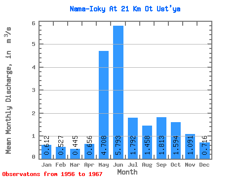
| Statistic | Jan | Feb | Mar | Apr | May | Jun | Jul | Aug | Sep | Oct | Nov | Dec | Annual |
|---|---|---|---|---|---|---|---|---|---|---|---|---|---|
| Mean | 0.61 | 0.53 | 0.45 | 0.66 | 4.71 | 5.79 | 1.79 | 1.46 | 1.81 | 1.59 | 1.09 | 0.72 | 1.79 |
| Standard Deviation | 0.17 | 0.12 | 0.10 | 0.52 | 2.75 | 3.06 | 0.64 | 0.79 | 0.91 | 0.89 | 0.34 | 0.15 | 0.29 |
| Min | 0.29 | 0.29 | 0.26 | 0.31 | 0.88 | 1.55 | 0.40 | 0.52 | 0.99 | 0.80 | 0.57 | 0.50 | 1.25 |
| Max | 0.81 | 0.65 | 0.60 | 2.08 | 10.00 | 10.20 | 2.53 | 2.88 | 3.90 | 3.82 | 1.59 | 0.90 | 2.11 |
| Coefficient of Variation | 0.28 | 0.24 | 0.22 | 0.80 | 0.58 | 0.53 | 0.36 | 0.54 | 0.50 | 0.56 | 0.31 | 0.21 | 0.17 |
 Return to R-Arctic Net Home Page