|
|
|||||||||||||||||
| Point ID: 8947 | Downloads | Plots | Site Data | Code: 71020 |
|
|
|||||||||||||||||
| Download | |
|---|---|
| Site Descriptor Information | Site Time Series Data |
| Link to all available data | |
| View: | Time Series | All |
| Units: | m3/s |
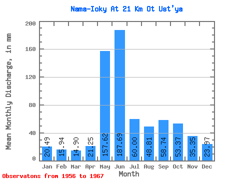
| Statistic | Jan | Feb | Mar | Apr | May | Jun | Jul | Aug | Sep | Oct | Nov | Dec | Annual |
|---|---|---|---|---|---|---|---|---|---|---|---|---|---|
| Mean | 20.49 | 16.07 | 14.90 | 21.25 | 157.60 | 187.71 | 59.99 | 48.80 | 58.74 | 53.36 | 35.35 | 23.97 | 705.77 |
| Standard Deviation | 5.71 | 3.79 | 3.22 | 16.98 | 91.89 | 99.05 | 21.50 | 26.30 | 29.55 | 29.63 | 10.92 | 4.93 | 116.10 |
| Min | 9.71 | 8.85 | 8.70 | 10.04 | 29.46 | 50.24 | 13.39 | 17.43 | 32.08 | 26.78 | 18.47 | 16.74 | 493.18 |
| Max | 27.11 | 19.82 | 20.09 | 67.39 | 334.75 | 330.48 | 84.69 | 96.41 | 126.36 | 127.87 | 51.52 | 30.13 | 833.71 |
| Coefficient of Variation | 0.28 | 0.24 | 0.22 | 0.80 | 0.58 | 0.53 | 0.36 | 0.54 | 0.50 | 0.56 | 0.31 | 0.21 | 0.17 |
 Return to R-Arctic Net Home Page