|
|
|||||||||||||||||
| Point ID: 8935 | Downloads | Plots | Site Data | Code: 70607 |
|
|
|||||||||||||||||
| Download | |
|---|---|
| Site Descriptor Information | Site Time Series Data |
| Link to all available data | |
| View: | Time Series | All |
| Units: | mm |
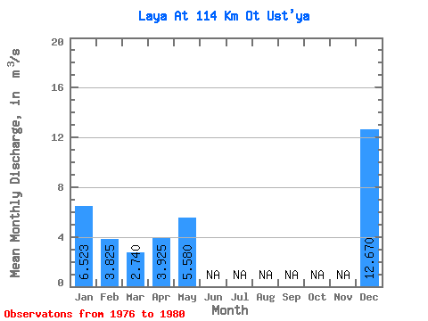
| Statistic | Jan | Feb | Mar | Apr | May | Jun | Jul | Aug | Sep | Oct | Nov | Dec | Annual |
|---|---|---|---|---|---|---|---|---|---|---|---|---|---|
| Mean | 6.52 | 3.83 | 2.74 | 3.92 | 5.58 | 12.67 | |||||||
| Standard Deviation | 3.66 | 1.70 | 1.13 | 0.54 | 5.13 | ||||||||
| Min | 2.30 | 1.61 | 1.15 | 3.54 | 5.58 | 9.04 | |||||||
| Max | 8.78 | 5.49 | 4.14 | 4.31 | 5.58 | 16.30 | |||||||
| Coefficient of Variation | 0.56 | 0.45 | 0.41 | 0.14 | 0.41 |
 Return to R-Arctic Net Home Page