|
|
| Point ID: 8935 | Downloads | Plots | Site Data | Code: 70607 |
|
| Download | |
|---|---|
| Site Descriptor Information | Site Time Series Data |
| Link to all available data | |
|
|
|
| View: | Statistics | All |
| Units: | mm |
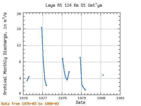
| Year | Jan | Feb | Mar | Apr | May | Jun | Jul | Aug | Sep | Oct | Nov | Dec | Annual | 1976 | 3.34 | 4.31 | 16.30 | 1977 | 8.49 | 3.44 | 2.26 | 1978 | 8.78 | 5.49 | 4.14 | 3.54 | 5.58 | 9.04 | 1979 | 2.30 | 1.61 | 1.15 | 1980 | 4.76 | 2.81 |
|---|
 Return to R-Arctic Net Home Page