|
|
|||||||||||||||||
| Point ID: 892 | Downloads | Plots | Site Data | Code: 07FC002 |
|
|
|||||||||||||||||
| Download | |
|---|---|
| Site Descriptor Information | Site Time Series Data |
| Link to all available data | |
| View: | Time Series | All |
| Units: | mm |
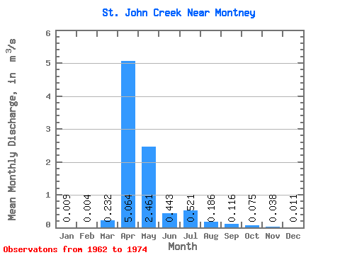
| Statistic | Jan | Feb | Mar | Apr | May | Jun | Jul | Aug | Sep | Oct | Nov | Dec | Annual |
|---|---|---|---|---|---|---|---|---|---|---|---|---|---|
| Mean | 0.01 | 0.00 | 0.23 | 5.06 | 2.46 | 0.44 | 0.52 | 0.19 | 0.12 | 0.07 | 0.04 | 0.01 | 0.72 |
| Standard Deviation | 0.02 | 0.01 | 0.44 | 3.79 | 2.29 | 0.66 | 0.66 | 0.32 | 0.21 | 0.12 | 0.05 | 0.02 | 0.40 |
| Min | 0.00 | 0.00 | 0.00 | 0.88 | 0.22 | 0.02 | 0.01 | 0.00 | 0.00 | 0.00 | 0.00 | 0.00 | 0.23 |
| Max | 0.05 | 0.02 | 1.23 | 13.10 | 7.96 | 2.37 | 1.89 | 1.04 | 0.80 | 0.40 | 0.14 | 0.04 | 1.48 |
| Coefficient of Variation | 1.65 | 1.53 | 1.92 | 0.75 | 0.93 | 1.48 | 1.26 | 1.70 | 1.85 | 1.55 | 1.34 | 1.38 | 0.55 |
 Return to R-Arctic Net Home Page