|
|
|||||||||||||||||
| Point ID: 892 | Downloads | Plots | Site Data | Code: 07FC002 |
|
|
|||||||||||||||||
| Download | |
|---|---|
| Site Descriptor Information | Site Time Series Data |
| Link to all available data | |
| View: | Time Series | All |
| Units: | m3/s |
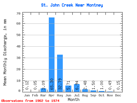
| Statistic | Jan | Feb | Mar | Apr | May | Jun | Jul | Aug | Sep | Oct | Nov | Dec | Annual |
|---|---|---|---|---|---|---|---|---|---|---|---|---|---|
| Mean | 0.13 | 0.04 | 3.09 | 65.31 | 32.79 | 5.71 | 6.94 | 2.48 | 1.50 | 1.00 | 0.49 | 0.15 | 113.17 |
| Standard Deviation | 0.21 | 0.07 | 5.91 | 48.81 | 30.48 | 8.47 | 8.76 | 4.22 | 2.78 | 1.55 | 0.65 | 0.21 | 62.12 |
| Min | 0.00 | 0.00 | 0.00 | 11.32 | 2.97 | 0.26 | 0.16 | 0.00 | 0.00 | 0.00 | 0.00 | 0.00 | 36.90 |
| Max | 0.64 | 0.19 | 16.39 | 168.93 | 106.05 | 30.56 | 25.18 | 13.86 | 10.34 | 5.33 | 1.84 | 0.59 | 232.28 |
| Coefficient of Variation | 1.65 | 1.53 | 1.92 | 0.75 | 0.93 | 1.48 | 1.26 | 1.70 | 1.85 | 1.55 | 1.34 | 1.38 | 0.55 |
 Return to R-Arctic Net Home Page