|
|
|||||||||||||||||
| Point ID: 8918 | Downloads | Plots | Site Data | Code: 70582 |
|
|
|||||||||||||||||
| Download | |
|---|---|
| Site Descriptor Information | Site Time Series Data |
| Link to all available data | |
| View: | Time Series | All |
| Units: | mm |
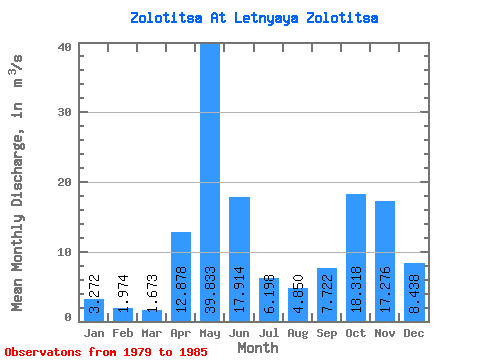
| Statistic | Jan | Feb | Mar | Apr | May | Jun | Jul | Aug | Sep | Oct | Nov | Dec | Annual |
|---|---|---|---|---|---|---|---|---|---|---|---|---|---|
| Mean | 3.27 | 1.97 | 1.67 | 12.88 | 39.83 | 17.91 | 6.20 | 4.85 | 7.72 | 18.32 | 17.28 | 8.44 | 16.18 |
| Standard Deviation | 1.25 | 0.80 | 0.57 | 14.74 | 3.95 | 16.34 | 4.44 | 2.94 | 5.06 | 14.86 | 10.87 | 6.17 | |
| Min | 2.07 | 1.08 | 1.08 | 0.95 | 36.30 | 5.07 | 2.92 | 2.05 | 3.75 | 5.49 | 8.67 | 3.58 | 16.18 |
| Max | 4.98 | 3.06 | 2.32 | 34.40 | 44.10 | 46.40 | 12.70 | 8.27 | 15.80 | 43.90 | 34.40 | 18.60 | 16.18 |
| Coefficient of Variation | 0.38 | 0.40 | 0.34 | 1.14 | 0.10 | 0.91 | 0.72 | 0.61 | 0.66 | 0.81 | 0.63 | 0.73 |
 Return to R-Arctic Net Home Page