|
|
| Point ID: 8918 | Downloads | Plots | Site Data | Code: 70582 |
|
| Download | |
|---|---|
| Site Descriptor Information | Site Time Series Data |
| Link to all available data | |
|
|
|
| View: | Statistics | All |
| Units: | mm |
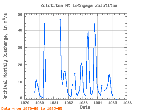
| Year | Jan | Feb | Mar | Apr | May | Jun | Jul | Aug | Sep | Oct | Nov | Dec | Annual | 1979 | 3.75 | 11.60 | 8.67 | 7.00 | 1980 | 2.62 | 1.51 | 1.08 | 0.95 | 44.10 | 10.40 | 1981 | 46.40 | 12.70 | 8.27 | 15.80 | 16.00 | 9.41 | 3.71 | 1982 | 2.49 | 1.72 | 1.32 | 8.30 | 14.70 | 3.89 | 2.05 | 3.91 | 5.49 | 21.60 | 18.60 | 1983 | 4.20 | 2.50 | 1.97 | 34.40 | 39.10 | 13.00 | 2.92 | 2.78 | 5.74 | 43.90 | 34.40 | 9.30 | 16.18 | 1984 | 4.98 | 3.06 | 2.32 | 7.86 | 5.07 | 5.28 | 6.30 | 9.41 | 14.60 | 12.30 | 3.58 | 1985 | 2.07 | 1.08 | 36.30 |
|---|
 Return to R-Arctic Net Home Page