|
|
|||||||||||||||||
| Point ID: 890 | Downloads | Plots | Site Data | Code: 07FB011 |
|
|
|||||||||||||||||
| Download | |
|---|---|
| Site Descriptor Information | Site Time Series Data |
| Link to all available data | |
| View: | Time Series | All |
| Units: | mm |
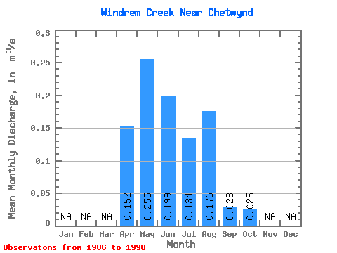
| Statistic | Jan | Feb | Mar | Apr | May | Jun | Jul | Aug | Sep | Oct | Nov | Dec | Annual |
|---|---|---|---|---|---|---|---|---|---|---|---|---|---|
| Mean | 0.15 | 0.26 | 0.20 | 0.13 | 0.18 | 0.03 | 0.03 | ||||||
| Standard Deviation | 0.11 | 0.19 | 0.16 | 0.11 | 0.52 | 0.04 | 0.04 | ||||||
| Min | 0.04 | 0.10 | 0.01 | 0.00 | 0.00 | 0.00 | 0.00 | ||||||
| Max | 0.33 | 0.79 | 0.54 | 0.35 | 1.82 | 0.12 | 0.11 | ||||||
| Coefficient of Variation | 0.73 | 0.74 | 0.82 | 0.82 | 2.94 | 1.49 | 1.72 |
 Return to R-Arctic Net Home Page