|
|
|||||||||||||||||
| Point ID: 890 | Downloads | Plots | Site Data | Code: 07FB011 |
|
|
|||||||||||||||||
| Download | |
|---|---|
| Site Descriptor Information | Site Time Series Data |
| Link to all available data | |
| View: | Time Series | All |
| Units: | m3/s |
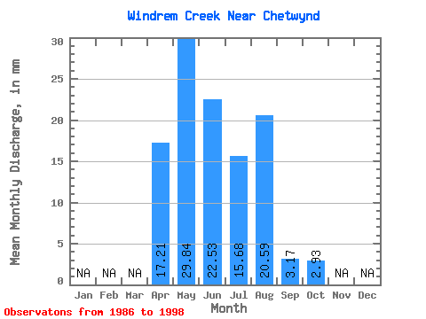
| Statistic | Jan | Feb | Mar | Apr | May | Jun | Jul | Aug | Sep | Oct | Nov | Dec | Annual |
|---|---|---|---|---|---|---|---|---|---|---|---|---|---|
| Mean | 17.17 | 29.84 | 22.56 | 15.72 | 20.63 | 3.14 | 2.96 | ||||||
| Standard Deviation | 12.62 | 22.12 | 18.62 | 12.95 | 60.70 | 4.68 | 5.09 | ||||||
| Min | 4.98 | 11.82 | 1.70 | 0.00 | 0.00 | 0.00 | 0.00 | ||||||
| Max | 37.03 | 92.19 | 60.70 | 40.71 | 212.93 | 13.81 | 13.10 | ||||||
| Coefficient of Variation | 0.73 | 0.74 | 0.82 | 0.82 | 2.94 | 1.49 | 1.72 |
 Return to R-Arctic Net Home Page