|
|
|||||||||||||||||
| Point ID: 8883 | Downloads | Plots | Site Data | Code: 70500 |
|
|
|||||||||||||||||
| Download | |
|---|---|
| Site Descriptor Information | Site Time Series Data |
| Link to all available data | |
| View: | Time Series | All |
| Units: | mm |
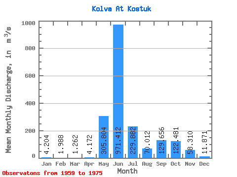
| Statistic | Jan | Feb | Mar | Apr | May | Jun | Jul | Aug | Sep | Oct | Nov | Dec | Annual |
|---|---|---|---|---|---|---|---|---|---|---|---|---|---|
| Mean | 4.20 | 1.99 | 1.26 | 4.17 | 305.80 | 971.41 | 229.88 | 70.01 | 129.66 | 122.48 | 58.31 | 11.87 | 156.71 |
| Standard Deviation | 3.04 | 1.50 | 0.85 | 7.21 | 336.03 | 321.22 | 131.99 | 44.67 | 73.14 | 58.45 | 75.08 | 8.59 | 30.19 |
| Min | 0.90 | 0.14 | 0.08 | 0.10 | 0.12 | 450.00 | 101.00 | 20.20 | 12.60 | 15.10 | 6.16 | 2.07 | 113.27 |
| Max | 14.30 | 6.44 | 2.97 | 23.10 | 978.00 | 1570.00 | 571.00 | 155.00 | 236.00 | 226.00 | 318.00 | 34.10 | 202.40 |
| Coefficient of Variation | 0.72 | 0.76 | 0.67 | 1.73 | 1.10 | 0.33 | 0.57 | 0.64 | 0.56 | 0.48 | 1.29 | 0.72 | 0.19 |
 Return to R-Arctic Net Home Page