|
|
|||||||||||||||||
| Point ID: 8883 | Downloads | Plots | Site Data | Code: 70500 |
|
|
|||||||||||||||||
| Download | |
|---|---|
| Site Descriptor Information | Site Time Series Data |
| Link to all available data | |
| View: | Time Series | All |
| Units: | m3/s |
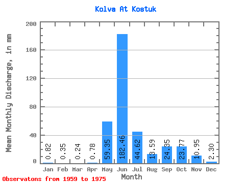
| Statistic | Jan | Feb | Mar | Apr | May | Jun | Jul | Aug | Sep | Oct | Nov | Dec | Annual |
|---|---|---|---|---|---|---|---|---|---|---|---|---|---|
| Mean | 0.82 | 0.35 | 0.24 | 0.78 | 59.34 | 182.46 | 44.61 | 13.59 | 24.35 | 23.77 | 10.95 | 2.30 | 358.38 |
| Standard Deviation | 0.59 | 0.27 | 0.17 | 1.35 | 65.21 | 60.33 | 25.61 | 8.67 | 13.74 | 11.34 | 14.10 | 1.67 | 69.04 |
| Min | 0.17 | 0.03 | 0.02 | 0.02 | 0.02 | 84.52 | 19.60 | 3.92 | 2.37 | 2.93 | 1.16 | 0.40 | 259.03 |
| Max | 2.77 | 1.14 | 0.58 | 4.34 | 189.79 | 294.89 | 110.81 | 30.08 | 44.33 | 43.86 | 59.73 | 6.62 | 462.89 |
| Coefficient of Variation | 0.72 | 0.76 | 0.67 | 1.73 | 1.10 | 0.33 | 0.57 | 0.64 | 0.56 | 0.48 | 1.29 | 0.72 | 0.19 |
 Return to R-Arctic Net Home Page