|
|
|||||||||||||||||
| Point ID: 888 | Downloads | Plots | Site Data | Code: 07FB009 |
|
|
|||||||||||||||||
| Download | |
|---|---|
| Site Descriptor Information | Site Time Series Data |
| Link to all available data | |
| View: | Time Series | All |
| Units: | mm |
| Statistic | Jan | Feb | Mar | Apr | May | Jun | Jul | Aug | Sep | Oct | Nov | Dec | Annual |
|---|---|---|---|---|---|---|---|---|---|---|---|---|---|
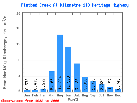
| Mean | 0.57 | 0.47 | 0.67 | 5.17 | 14.39 | 11.33 | 7.13 | 3.84 | 2.78 | 2.03 | 1.16 | 0.74 | 4.03 |
| Standard Deviation | 0.28 | 0.23 | 0.48 | 2.82 | 5.40 | 6.68 | 5.84 | 5.54 | 3.00 | 1.48 | 0.57 | 0.37 | 1.30 |
| Min | 0.15 | 0.11 | 0.17 | 1.24 | 5.34 | 3.38 | 0.39 | 0.51 | 0.43 | 0.55 | 0.52 | 0.23 | 1.71 |
| Max | 1.22 | 1.05 | 2.33 | 10.60 | 28.40 | 31.50 | 18.50 | 21.70 | 10.90 | 5.27 | 2.34 | 1.89 | 7.05 |
| Coefficient of Variation | 0.48 | 0.48 | 0.72 | 0.55 | 0.38 | 0.59 | 0.82 | 1.45 | 1.08 | 0.73 | 0.49 | 0.50 | 0.32 |
 Return to R-Arctic Net Home Page