|
|
|||||||||||||||||
| Point ID: 888 | Downloads | Plots | Site Data | Code: 07FB009 |
|
|
|||||||||||||||||
| Download | |
|---|---|
| Site Descriptor Information | Site Time Series Data |
| Link to all available data | |
| View: | Time Series | All |
| Units: | m3/s |
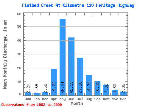
| Statistic | Jan | Feb | Mar | Apr | May | Jun | Jul | Aug | Sep | Oct | Nov | Dec | Annual |
|---|---|---|---|---|---|---|---|---|---|---|---|---|---|
| Mean | 2.20 | 1.66 | 2.58 | 19.22 | 55.31 | 42.13 | 27.38 | 14.74 | 10.33 | 7.81 | 4.30 | 2.86 | 182.50 |
| Standard Deviation | 1.06 | 0.79 | 1.85 | 10.47 | 20.76 | 24.84 | 22.45 | 21.30 | 11.17 | 5.70 | 2.11 | 1.43 | 58.91 |
| Min | 0.56 | 0.38 | 0.67 | 4.61 | 20.52 | 12.57 | 1.50 | 1.95 | 1.59 | 2.11 | 1.93 | 0.90 | 77.51 |
| Max | 4.69 | 3.68 | 8.95 | 39.42 | 109.12 | 117.14 | 71.08 | 83.38 | 40.53 | 20.25 | 8.70 | 7.26 | 319.33 |
| Coefficient of Variation | 0.48 | 0.48 | 0.72 | 0.55 | 0.38 | 0.59 | 0.82 | 1.45 | 1.08 | 0.73 | 0.49 | 0.50 | 0.32 |
 Return to R-Arctic Net Home Page