|
|
|||||||||||||||||
| Point ID: 8852 | Downloads | Plots | Site Data | Code: 70268 |
|
|
|||||||||||||||||
| Download | |
|---|---|
| Site Descriptor Information | Site Time Series Data |
| Link to all available data | |
| View: | Time Series | All |
| Units: | mm |
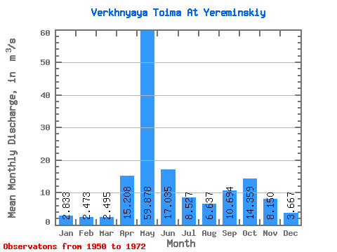
| Statistic | Jan | Feb | Mar | Apr | May | Jun | Jul | Aug | Sep | Oct | Nov | Dec | Annual |
|---|---|---|---|---|---|---|---|---|---|---|---|---|---|
| Mean | 2.83 | 2.47 | 2.50 | 15.21 | 59.88 | 17.04 | 8.53 | 6.64 | 10.69 | 14.36 | 8.15 | 3.67 | 12.70 |
| Standard Deviation | 0.75 | 0.55 | 0.31 | 14.82 | 26.00 | 9.02 | 5.21 | 4.63 | 6.31 | 6.73 | 3.47 | 1.30 | 2.76 |
| Min | 1.55 | 1.45 | 1.85 | 2.40 | 12.70 | 5.16 | 3.11 | 2.43 | 3.94 | 5.26 | 2.90 | 1.88 | 7.18 |
| Max | 4.65 | 3.72 | 2.96 | 57.10 | 105.00 | 40.30 | 21.20 | 21.80 | 26.00 | 28.80 | 14.30 | 7.85 | 17.68 |
| Coefficient of Variation | 0.26 | 0.22 | 0.12 | 0.97 | 0.43 | 0.53 | 0.61 | 0.70 | 0.59 | 0.47 | 0.43 | 0.35 | 0.22 |
 Return to R-Arctic Net Home Page