|
|
|||||||||||||||||
| Point ID: 8852 | Downloads | Plots | Site Data | Code: 70268 |
|
|
|||||||||||||||||
| Download | |
|---|---|
| Site Descriptor Information | Site Time Series Data |
| Link to all available data | |
| View: | Time Series | All |
| Units: | m3/s |
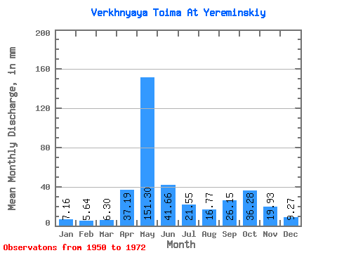
| Statistic | Jan | Feb | Mar | Apr | May | Jun | Jul | Aug | Sep | Oct | Nov | Dec | Annual |
|---|---|---|---|---|---|---|---|---|---|---|---|---|---|
| Mean | 7.16 | 5.69 | 6.30 | 37.19 | 151.28 | 41.66 | 21.54 | 16.77 | 26.15 | 36.28 | 19.93 | 9.26 | 378.22 |
| Standard Deviation | 1.88 | 1.26 | 0.78 | 36.25 | 65.69 | 22.07 | 13.17 | 11.69 | 15.44 | 17.01 | 8.49 | 3.29 | 82.28 |
| Min | 3.92 | 3.34 | 4.67 | 5.87 | 32.09 | 12.62 | 7.86 | 6.14 | 9.63 | 13.29 | 7.09 | 4.75 | 213.68 |
| Max | 11.75 | 8.56 | 7.48 | 139.63 | 265.27 | 98.55 | 53.56 | 55.08 | 63.58 | 72.76 | 34.97 | 19.83 | 526.42 |
| Coefficient of Variation | 0.26 | 0.22 | 0.12 | 0.97 | 0.43 | 0.53 | 0.61 | 0.70 | 0.59 | 0.47 | 0.43 | 0.35 | 0.22 |
 Return to R-Arctic Net Home Page