|
|
|||||||||||||||||
| Point ID: 8841 | Downloads | Plots | Site Data | Code: 70115 |
|
|
|||||||||||||||||
| Download | |
|---|---|
| Site Descriptor Information | Site Time Series Data |
| Link to all available data | |
| View: | Time Series | All |
| Units: | mm |
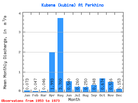
| Statistic | Jan | Feb | Mar | Apr | May | Jun | Jul | Aug | Sep | Oct | Nov | Dec | Annual |
|---|---|---|---|---|---|---|---|---|---|---|---|---|---|
| Mean | 0.07 | 0.05 | 0.05 | 1.99 | 3.70 | 0.54 | 0.26 | 0.25 | 0.35 | 0.67 | 0.52 | 0.15 | 0.72 |
| Standard Deviation | 0.04 | 0.03 | 0.03 | 1.47 | 2.02 | 0.50 | 0.28 | 0.32 | 0.38 | 0.49 | 0.41 | 0.14 | 0.23 |
| Min | 0.01 | 0.01 | 0.01 | 0.18 | 0.99 | 0.16 | 0.02 | 0.01 | 0.01 | 0.04 | 0.12 | 0.03 | 0.43 |
| Max | 0.20 | 0.13 | 0.15 | 5.65 | 8.55 | 2.31 | 1.09 | 1.13 | 1.52 | 1.93 | 1.61 | 0.70 | 1.26 |
| Coefficient of Variation | 0.56 | 0.64 | 0.72 | 0.74 | 0.55 | 0.93 | 1.07 | 1.26 | 1.09 | 0.73 | 0.80 | 0.94 | 0.32 |
 Return to R-Arctic Net Home Page