|
|
|||||||||||||||||
| Point ID: 8841 | Downloads | Plots | Site Data | Code: 70115 |
|
|
|||||||||||||||||
| Download | |
|---|---|
| Site Descriptor Information | Site Time Series Data |
| Link to all available data | |
| View: | Time Series | All |
| Units: | m3/s |
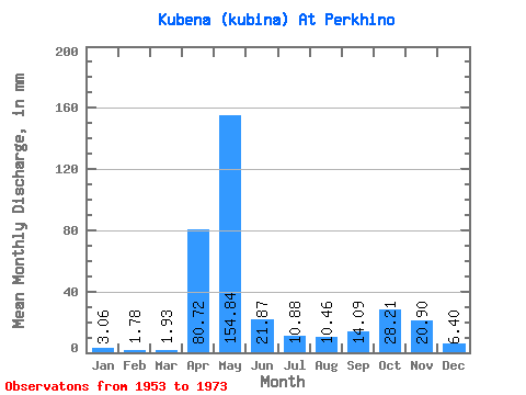
| Statistic | Jan | Feb | Mar | Apr | May | Jun | Jul | Aug | Sep | Oct | Nov | Dec | Annual |
|---|---|---|---|---|---|---|---|---|---|---|---|---|---|
| Mean | 3.06 | 1.80 | 1.91 | 80.74 | 154.82 | 21.87 | 10.88 | 10.46 | 14.08 | 28.22 | 20.90 | 6.39 | 353.30 |
| Standard Deviation | 1.70 | 1.16 | 1.39 | 59.58 | 84.31 | 20.25 | 11.64 | 13.18 | 15.41 | 20.72 | 16.68 | 5.98 | 113.10 |
| Min | 0.38 | 0.23 | 0.63 | 7.29 | 41.42 | 6.48 | 0.67 | 0.38 | 0.41 | 1.63 | 4.86 | 1.21 | 212.29 |
| Max | 8.37 | 4.96 | 6.28 | 228.82 | 357.76 | 93.56 | 45.61 | 47.28 | 61.56 | 80.76 | 65.20 | 29.29 | 622.20 |
| Coefficient of Variation | 0.56 | 0.64 | 0.72 | 0.74 | 0.55 | 0.93 | 1.07 | 1.26 | 1.09 | 0.73 | 0.80 | 0.94 | 0.32 |
 Return to R-Arctic Net Home Page