|
|
|||||||||||||||||
| Point ID: 8825 | Downloads | Plots | Site Data | Code: 70015 |
|
|
|||||||||||||||||
| Download | |
|---|---|
| Site Descriptor Information | Site Time Series Data |
| Link to all available data | |
| View: | Time Series | All |
| Units: | mm |
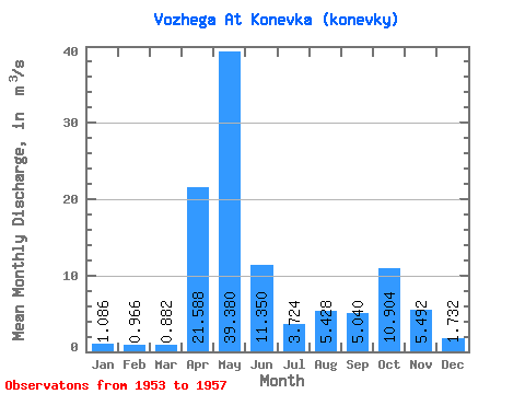
| Statistic | Jan | Feb | Mar | Apr | May | Jun | Jul | Aug | Sep | Oct | Nov | Dec | Annual |
|---|---|---|---|---|---|---|---|---|---|---|---|---|---|
| Mean | 1.09 | 0.97 | 0.88 | 21.59 | 39.38 | 11.35 | 3.72 | 5.43 | 5.04 | 10.90 | 5.49 | 1.73 | 8.96 |
| Standard Deviation | 0.37 | 0.39 | 0.28 | 16.34 | 19.36 | 11.30 | 1.67 | 3.06 | 3.35 | 6.11 | 3.83 | 0.82 | 2.10 |
| Min | 0.61 | 0.74 | 0.59 | 5.45 | 13.70 | 2.51 | 1.78 | 1.02 | 0.78 | 2.40 | 1.83 | 0.71 | 6.28 |
| Max | 1.49 | 1.65 | 1.34 | 47.30 | 62.60 | 24.50 | 6.13 | 9.32 | 9.03 | 18.60 | 11.00 | 2.62 | 10.70 |
| Coefficient of Variation | 0.34 | 0.40 | 0.32 | 0.76 | 0.49 | 1.00 | 0.45 | 0.56 | 0.67 | 0.56 | 0.70 | 0.47 | 0.23 |
 Return to R-Arctic Net Home Page