|
|
|||||||||||||||||
| Point ID: 8825 | Downloads | Plots | Site Data | Code: 70015 |
|
|
|||||||||||||||||
| Download | |
|---|---|
| Site Descriptor Information | Site Time Series Data |
| Link to all available data | |
| View: | Time Series | All |
| Units: | m3/s |
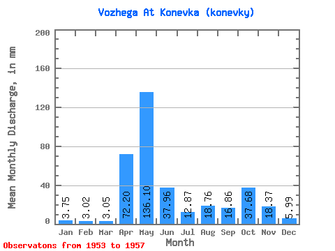
| Statistic | Jan | Feb | Mar | Apr | May | Jun | Jul | Aug | Sep | Oct | Nov | Dec | Annual |
|---|---|---|---|---|---|---|---|---|---|---|---|---|---|
| Mean | 3.75 | 3.04 | 3.05 | 72.20 | 136.08 | 37.96 | 12.87 | 18.76 | 16.86 | 37.68 | 18.37 | 5.99 | 365.05 |
| Standard Deviation | 1.27 | 1.21 | 0.96 | 54.66 | 66.88 | 37.81 | 5.77 | 10.59 | 11.21 | 21.11 | 12.82 | 2.83 | 85.59 |
| Min | 2.11 | 2.33 | 2.04 | 18.23 | 47.34 | 8.39 | 6.15 | 3.52 | 2.61 | 8.29 | 6.12 | 2.45 | 255.60 |
| Max | 5.15 | 5.20 | 4.63 | 158.20 | 216.31 | 81.94 | 21.18 | 32.20 | 30.20 | 64.27 | 36.79 | 9.05 | 435.56 |
| Coefficient of Variation | 0.34 | 0.40 | 0.32 | 0.76 | 0.49 | 1.00 | 0.45 | 0.56 | 0.67 | 0.56 | 0.70 | 0.47 | 0.23 |
 Return to R-Arctic Net Home Page